-
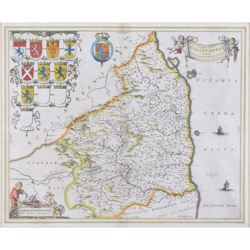
Johannes 'Joan' Blaeu (1596 - 1673)
Comitatus Northumbria, Vernacular Northumberland (1662)
Engraving with later hand-colouring 43 x 52 cm A decorative map of Northumberland by the celebrated Dutch mapmaker and artist Joan Blaeu, (son of the cartographer Willem Blaeu). Crests of the local gentry appear in the top right hand corner. Blaeu moved to Amsterdam in 1920 to join the family firm of mapmakers. In 1635, the business published the Theatrum orbis terrarum, sive, Atlas novus in two volumes - the largest and most expensive book published in the seventeenth century, and the venture for which the Blaeu were most famed. Joan and his brother Cornelius took over the studio after their father died in 1638; Joan became the official cartographer for the Dutch East India Company, as his father had been before him. Condition: very good. If you are interested, please email info@manningfineart.co.uk or call us on 07929 749056. Click here for other maps. -
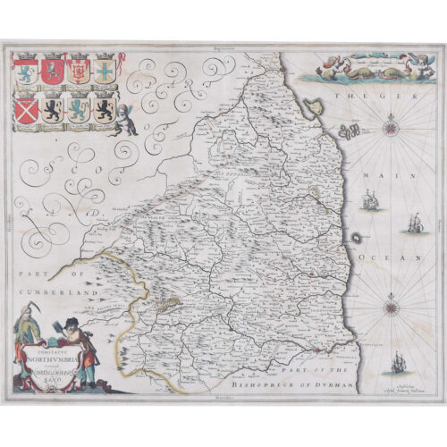
Joannem Janssonium (1588 - 1664)
Map of Northumberland (1646)
Engraving 41 x 50 cm The 1646 Latin edition. A decorative map of Northumberland by the noted Dutch mapmaker and publisher Joannem Janssonium. Condition: very good; later hand coloured. If you are interested, please email info@manningfineart.co.uk or call us on 07929 749056. Click here for other maps. -
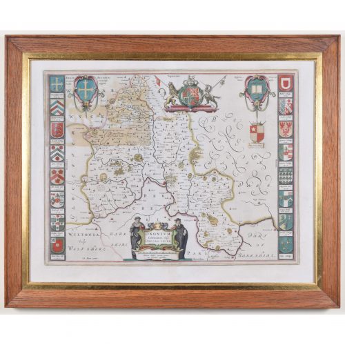
Johannes 'Joan' Blaeu (1596 - 1673)
Oxonium Comitatus, Vulgo Oxfordshire (1662)
Engraving with later hand-colouring 38 x 50 cm A decorative map of Oxfordshire by the celebrated Dutch mapmaker and artist Joan Blaeu, (son of the cartographer Willem Blaeu). Two Oxford scholars flanks the cartouche which declares the map to be of Oxonium (that is, Oxfordshire), and the design also features the arms of the British Royal Family, King Alfred, and the University of Oxford. Sixteen colleges crests border the map. Blaeu moved to Amsterdam in 1920 to join the family firm of mapmakers. In 1635, the business published the Theatrum orbis terrarum, sive, Atlas novus in two volumes - the largest and most expensive book published in the seventeenth century, and the venture for which the Blaeu were most famed. Joan and his brother Cornelius took over the studio after their father died in 1638; Joan became the official cartographer for the Dutch East India Company, as his father had been before him. Condition: mostly very good; area of toning to top left where coloured to reverse. Good oak frame. Framed with reverse visible. If you are interested, please email info@manningfineart.co.uk or call us on 07929 749056. Click here for other antique maps. -
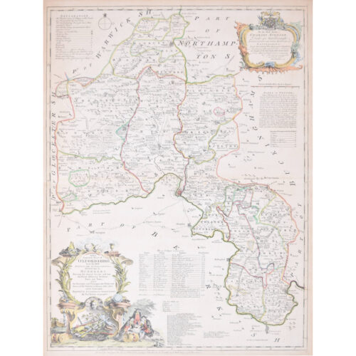
Thomas Kitchin (1719 - 1784)
Map of Oxfordshire (1764)
Engraving with later hand-colouring 72 x 54 cm This decorative map of Oxfordshire features a cartouche with three concentrating scholars and various educational trappings like rolls of parchment. The cartouche in the upper right corner dedicates the map to Charles Spencer, Duke of Marlborough, whose family seat of Blenheim Palace is just outside the city of Oxford. The map also sports a list of the University of Oxford's colleges, its rectories and vicarages, and a paragraph on the Earls of Oxford. Thomas Kitchin was an English engraver and cartographer. He was born in London and was apprenticed to the map engraver Emanuel Bowen in 1732. He produced John Elphinstone's map of Scotland (1746), the Geographia Scotiae (1749), and The Small English Atlas (1749) with Thomas Jefferys. Kitchen worked for the London Magazine and for the King; there is also some debate as to whether he passed off other cartographers' work as his own. Condition: generally very good; central fold as issued, another fold to middle of top half, three tiny losses (a millimetre or two) just outside plate mark to left side. If you are interested, please email info@manningfineart.co.uk or call us on 07929 749056. Click here for other decorative maps. -
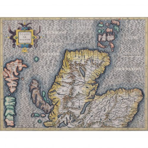
Gerardus Mercator (1512 - 1594)
Map of the North of Scotland (1683)
Engraving with later hand colouring 35 x 45 cm A fantastically characterful and detailed map engraving of the North of Scotland from 1683. The highly detailed and beautifully coloured map is inscribed to the reverse with a description of the parts of Scotland illustrated, called the ''Troisieme Table d''Escosse''. The map comes from the 1683 French edition of Gerardus Mercator''s Atlas Major, which was first published in 1585. Gerardus Mercator was the Flemish father of mapmaking. He was a skilled geographer, cosmographer and cartographer and is most renowned for creating the 1569 world map based on a new projection which represented sailing courses of constant bearing (rhumb lines) as straight lines - an innovation that is still employed in today''s nautical charts. Mercator was a highly influential pioneer in the history of cartography and is generally considered one of the founders of the Netherlandish school of cartography and geography. He is also widely considered the most notable figure of the school. In his own day, he was a notable maker of globes and scientific instruments. In addition, he had interests in theology, philosophy, history, mathematics and geomagnetism. He was also an accomplished engraver and calligrapher. Unlike other great scholars of the age, he travelled little and his knowledge of geography came from his library of over a thousand books and maps, from his visitors and from his vast correspondence (in six languages) with other scholars, statesmen, travellers, merchants and seamen. Mercator''s early maps were in large formats suitable for wall mounting but in the second half of his life, he produced over 100 new regional maps in a smaller format suitable for binding into his Atlas of 1595. This was the first appearance of the word Atlas in reference to a book of maps. However, Mercator used it as a neologism for a treatise (Cosmologia) on the creation, history and description of the universe, not simply a collection of maps. He chose the word as a commemoration of the Titan Atlas, "King of Mauretania", whom he considered to be the first great geographer. Mercator wrote on geography, philosophy, chronology and theology. All of the wall maps were engraved with copious text on the region concerned. As an example, the famous world map of 1569 is inscribed with over five thousand words in fifteen legends. Condition: a little spotting, primarily to margins. If you’d like to know more, please email info@manningfineart.co.uk or call us on 07929 749056. -

Macdonald (Max) Gill (1884-1947)
Australia: Her Natural and Industrial Resources (1950)
His Majesty’s Stationary Office, SO Code NO. 70-538-5-2 Lithographic poster 51 x 76cm (20 x 30 inches) Click here for biographical details and other works by the artist. Condition generally very good, a little spotting and the odd very short edge tear to margin not affecting image. If you are interested email info@manningfineart.co.uk or call us on 07929 749056. -
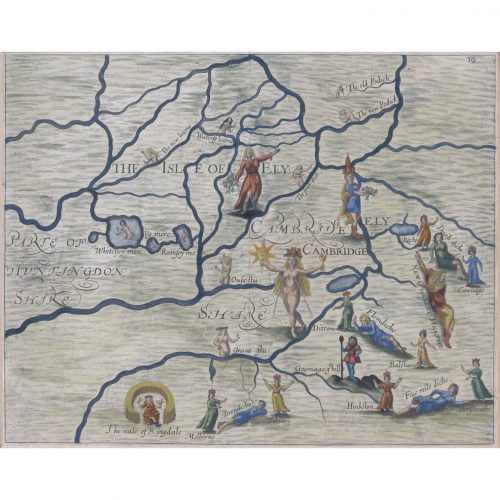
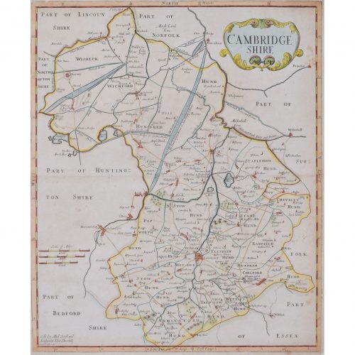
Map of Cambridge and the Isle of Ely (1622) engraved by William Hole for Drayton’s Poly Olbion
London (1622) 24 x 31 cm (9 x 12 in) If you are interested email info@manningfineart.co.uk or call us on 07929 749056. -
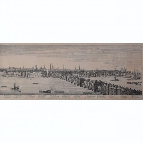
Samuel Buck (1696-1779) & Nathaniel Buck (active 1724-59) Panorama of the River Thames from Westminster Bridge to London Bridge
Published September 1749 30x404 cm Engraving Scroll down for further description. If you are interested email info@manningfineart.co.uk or call us on 07929 749056. -
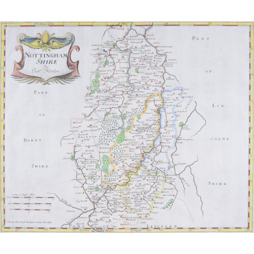
Robert Morden (1650-1703) Nottingham Shire (or Nottinghamshire)
Engraving with recent hand colouring 34x42cm First published in 1695 for Camden's Britannica (1695-1772) and reprinted several times during the succeeding century. -
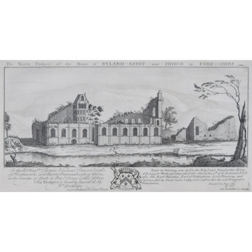
Samuel & Nathaniel Buck
Byland Abbey, Yorkshire
Engraving 37x19cm, c. 1770 "Byland Abbey is an interesting ruin about five miles from Helmsley. It was a fine specimen of ecclesiastical architecture, founded by the monks of Furness, who were driven from their establishment in Lancashire during an incursion of the Scots. When the abbey was dissolved in 1540 its revenues amounted to 238l. 9s. 4d." (Source: The Penny Magazine of the Society for the Diffusion of Useful Knowledge 25 June 1836.)