-
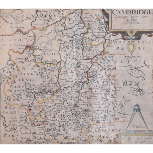
Sutton Nichols (1668 - 1729)
Map of Cambridgeshire
Engraving 43 x 36 cm Signed in plate lower left. A beautifully coloured 18th century map engraving of Cambridgeshire. The map was produced by Robert Morden for publication in Edward Gibson's 1695 translation of William Camden's Britannia, a topographical and historical survey of Great Britain and Ireland produced to "restore antiquity to Britaine, and Britain to his antiquity" - a most noble aim. William Camden (1551 - 1623) was an English antiquarian, historian, topographer, and herald, best known as the author of Britannia, the first chorographical survey of the islands of Great Britain and Ireland, and the Annales, the first detailed historical account of the Queen Elizabeth I's reign. Sutton Nicholls was a draughtsman and engraver best known for his panoramic views of the cities of London and Westminster. Almost all of his engravings were commissioned by publishers. Nicholls specialised in topographical and architectural designs; he also produced many maps, notably illustrating John Strype’s edition of John Stowe’s ‘Survey of London’ in 1720. Condition: good. Mounted to board. If you’d like to know more, please email info@manningfineart.co.uk or call us on 07929 749056. -
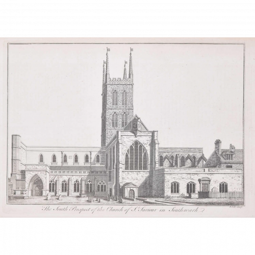
Benjamin Cole (1697-1783)
Southwark Cathedral (c. 1753)
Engraving 24 x 33 cm Stow's Survey of London, a ward-by-ward topographical and historical tour of the City of London giving an account of buildings, social conditions and customs, was first published in 1598. This view of Southwark Cathedral, labelled here as 'the South Prospect of the Church of St Saviour in Southwark', offers a charming perspective of the building's architecture and churchyard. Condition: Generally very good; slight offsetting from facing page and old library stamp to reverse. -
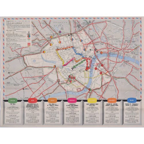
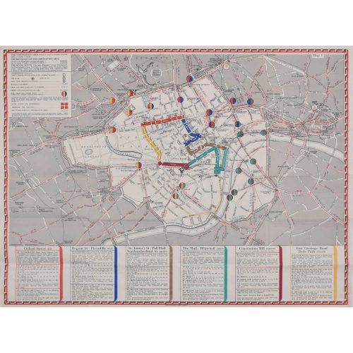
Coronation Arrangements - Map of London (1953)
Lithograph 45 x 60 cm (unfolded) Published by London Transport for the Coronation of Elizabeth II, this delightfully-coloured map illustrates the route taken by the Queen when she was crowned in 1953. Condition: generally very good. If you are interested, please email info@manningfineart.co.uk or call us on 07929 749056. -
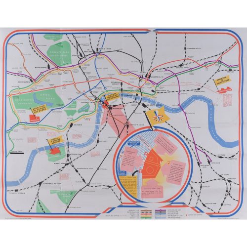
Coronation Arrangements - Map of London (1937)
Lithograph 45 x 60 cm (unfolded) Published by London Transport for the Coronation of George VI, this map illustrates the route the King took in 1936. And best of all, it's just (almost!) as useful in today's London. Condition: generally very good. If you are interested, please email info@manningfineart.co.uk or call us on 07929 749056. -
James Hart
Festival of Britain
Lithographic poster map 45 x 58 cm Folding map published for London Transport and British Railways for visitors to the 1951 Festival of Britain, featuring the Abram Games logo, details of water bus services, a detailed plan of the Lambeth exhibition area by Waterloo Bridge. If you are interested email info@manningfineart.co.uk or call us on 07929 749056. -
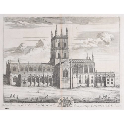
Johannes 'Jan' Kip (1652/3 - 1722)
The North Prospect of Gloster Cathedral (c.1716)
43 x 47 cm Copper engraving Johannes "Jan" Kip was a Dutch engraver, draughtsman and print dealer. After producing works for the court of William of Orange in Amsterdam, Kip followed William and Mary to London, settling in Farringdon and selling prints. Later, Kip collaborated with draughtsman and painter Leonard Knyff, and together they made a popular series of engraved views of English country houses. This print is from Sir Robert Atkyn's 'The Ancient and Present State of Gloucestershire'. In his usual manner - Kip was probably the foremost engraver of his time in England - he has placed figures before the Cathedral to give life - and scale - to the building. Condition: Generally very good with central vertical fold and adjacent parallel creases; one diagonal crease mid left to bottom centre. Will look very good when framed. -
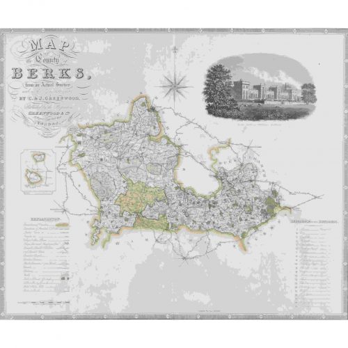
John Dower (1825 - 1901)
Map of Berkshire from an actual survey made in the years 1822 & 1823
Engraving 57 x 69 cm A large antique engraved map of Berkshire. Condition: good; some light staining. If you’d like to know more, please email info@manningfineart.co.uk or call us on 07929 749056. -
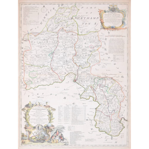
Thomas Kitchin (1719 - 1784)
Map of Oxfordshire (1764)
Engraving with later hand-colouring 72 x 54 cm This decorative map of Oxfordshire features a cartouche with three concentrating scholars and various educational trappings like rolls of parchment. The cartouche in the upper right corner dedicates the map to Charles Spencer, Duke of Marlborough, whose family seat of Blenheim Palace is just outside the city of Oxford. The map also sports a list of the University of Oxford's colleges, its rectories and vicarages, and a paragraph on the Earls of Oxford. Thomas Kitchin was an English engraver and cartographer. He was born in London and was apprenticed to the map engraver Emanuel Bowen in 1732. He produced John Elphinstone's map of Scotland (1746), the Geographia Scotiae (1749), and The Small English Atlas (1749) with Thomas Jefferys. Kitchen worked for the London Magazine and for the King; there is also some debate as to whether he passed off other cartographers' work as his own. Condition: generally very good; central fold as issued, another fold to middle of top half, three tiny losses (a millimetre or two) just outside plate mark to left side. If you are interested, please email info@manningfineart.co.uk or call us on 07929 749056. Click here for other decorative maps. -
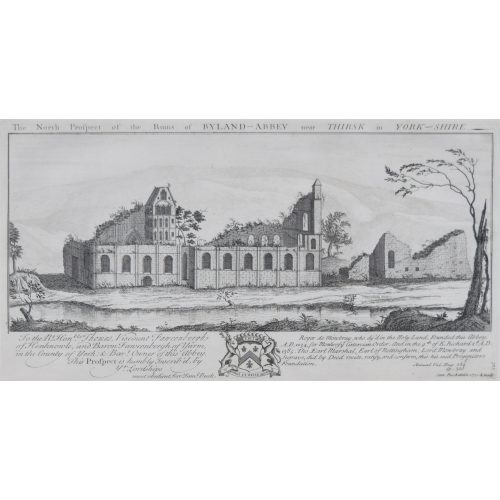
Samuel & Nathaniel Buck
Byland Abbey, Yorkshire
Engraving 37x19cm, c. 1770 "Byland Abbey is an interesting ruin about five miles from Helmsley. It was a fine specimen of ecclesiastical architecture, founded by the monks of Furness, who were driven from their establishment in Lancashire during an incursion of the Scots. When the abbey was dissolved in 1540 its revenues amounted to 238l. 9s. 4d." (Source: The Penny Magazine of the Society for the Diffusion of Useful Knowledge 25 June 1836.) -
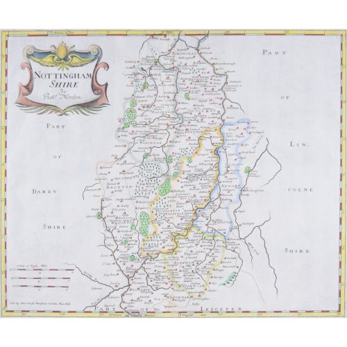
Robert Morden (1650-1703) Nottingham Shire (or Nottinghamshire)
Engraving with recent hand colouring 34x42cm First published in 1695 for Camden's Britannica (1695-1772) and reprinted several times during the succeeding century.