-
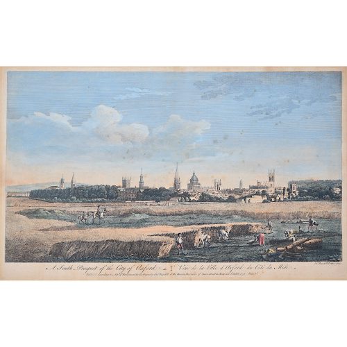
John Boydell (1719-1804)
A South Prospect of the City of Oxford
Hand-coloured engraving published 1751 in the series Four Views of Oxford 28x44.5cm If you are interested email info@manningfineart.co.uk or call us on 07929 749056. One of the most influential Georgian printsellers, Boydell was apprenticed to William Henry Toms at the age of 21, studying drawing at the St Marin's Lane Academy. From 1755 he imported foreign prints in great numbers. He became Mayor of London in 1790. -
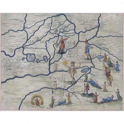
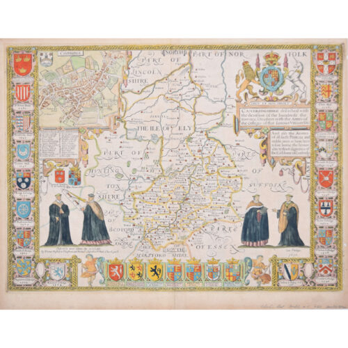
Map of Cambridge and the Isle of Ely (1622) engraved by William Hole for Drayton’s Poly Olbion
London (1622) 24 x 31 cm (9 x 12 in) If you are interested email info@manningfineart.co.uk or call us on 07929 749056. -
Joannem Janssonium (1588 - 1664)
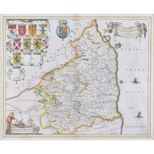
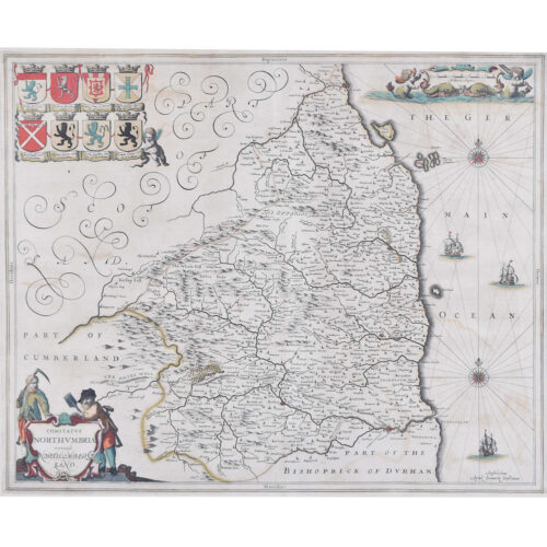
Map of Northumberland (1646)
Engraving 41 x 50 cm The 1646 Latin edition. A decorative map of Northumberland by the noted Dutch mapmaker and publisher Joannem Janssonium. Condition: very good; later hand coloured. If you are interested, please email info@manningfineart.co.uk or call us on 07929 749056. Click here for other maps. -
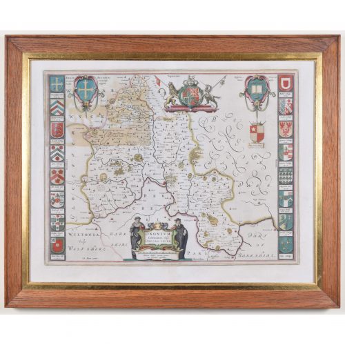
Johannes 'Joan' Blaeu (1596 - 1673)
Oxonium Comitatus, Vulgo Oxfordshire (1662)
Engraving with later hand-colouring 38 x 50 cm A decorative map of Oxfordshire by the celebrated Dutch mapmaker and artist Joan Blaeu, (son of the cartographer Willem Blaeu). Two Oxford scholars flanks the cartouche which declares the map to be of Oxonium (that is, Oxfordshire), and the design also features the arms of the British Royal Family, King Alfred, and the University of Oxford. Sixteen colleges crests border the map. Blaeu moved to Amsterdam in 1920 to join the family firm of mapmakers. In 1635, the business published the Theatrum orbis terrarum, sive, Atlas novus in two volumes - the largest and most expensive book published in the seventeenth century, and the venture for which the Blaeu were most famed. Joan and his brother Cornelius took over the studio after their father died in 1638; Joan became the official cartographer for the Dutch East India Company, as his father had been before him. Condition: mostly very good; area of toning to top left where coloured to reverse. Good oak frame. Framed with reverse visible. If you are interested, please email info@manningfineart.co.uk or call us on 07929 749056. Click here for other antique maps. -
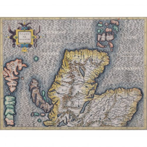
Gerardus Mercator (1512 - 1594)
Map of the North of Scotland (1683)
Engraving with later hand colouring 35 x 45 cm A fantastically characterful and detailed map engraving of the North of Scotland from 1683. The highly detailed and beautifully coloured map is inscribed to the reverse with a description of the parts of Scotland illustrated, called the ''Troisieme Table d''Escosse''. The map comes from the 1683 French edition of Gerardus Mercator''s Atlas Major, which was first published in 1585. Gerardus Mercator was the Flemish father of mapmaking. He was a skilled geographer, cosmographer and cartographer and is most renowned for creating the 1569 world map based on a new projection which represented sailing courses of constant bearing (rhumb lines) as straight lines - an innovation that is still employed in today''s nautical charts. Mercator was a highly influential pioneer in the history of cartography and is generally considered one of the founders of the Netherlandish school of cartography and geography. He is also widely considered the most notable figure of the school. In his own day, he was a notable maker of globes and scientific instruments. In addition, he had interests in theology, philosophy, history, mathematics and geomagnetism. He was also an accomplished engraver and calligrapher. Unlike other great scholars of the age, he travelled little and his knowledge of geography came from his library of over a thousand books and maps, from his visitors and from his vast correspondence (in six languages) with other scholars, statesmen, travellers, merchants and seamen. Mercator''s early maps were in large formats suitable for wall mounting but in the second half of his life, he produced over 100 new regional maps in a smaller format suitable for binding into his Atlas of 1595. This was the first appearance of the word Atlas in reference to a book of maps. However, Mercator used it as a neologism for a treatise (Cosmologia) on the creation, history and description of the universe, not simply a collection of maps. He chose the word as a commemoration of the Titan Atlas, "King of Mauretania", whom he considered to be the first great geographer. Mercator wrote on geography, philosophy, chronology and theology. All of the wall maps were engraved with copious text on the region concerned. As an example, the famous world map of 1569 is inscribed with over five thousand words in fifteen legends. Condition: a little spotting, primarily to margins. If you’d like to know more, please email info@manningfineart.co.uk or call us on 07929 749056. -
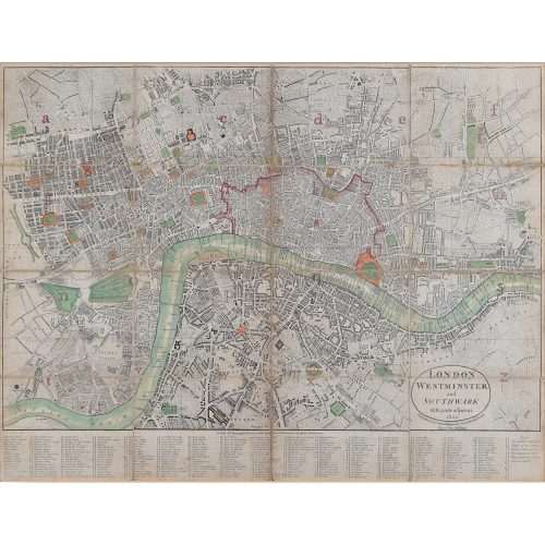
Darton and Harvey (publisher)
Map of London, Southwark, and parts adjacent (1800)
Engraving 42 x 56 cm Condition: generally very good; backed to linen with some evidence of use. -
John Speed (1551 or 1552 - 1629)
Map of Cambridgeshire
Engraving with later hand colouring 39 x 53 cm A beautifully coloured map of Cambridgeshire, with an antique description of the county to the reverse. The map, along with many others, was published in Speed's atlas, 'The Theatre of the Empire of Great Britaine', first published in 1611. The map is populated by four figures in academic dress, and bordered on all sides by college crests. John Speed was an English cartographer, chronologer and historian. The son of a citizen and Merchant Taylor in London, he rose from his family occupation to accept the task of drawing together and revising the histories, topographies and maps of the Kingdoms of Great Britain as an exposition of the union of their monarchies in the person of King James I and VI. He accomplished this with remarkable success, with the support and assistance of the leading antiquarian scholars of his generation. He drew upon and improved the shire maps of Christopher Saxton, John Norden and others, being the first to incorporate the hundred-boundaries into them, and he was the surveyor and originator of many of the town or city plans inset within them. His work helped to define early modern concepts of British national identity. His Biblical genealogies were also formally associated with the first edition of the King James Bible. He is among the most famous of English mapmakers. Condition: generally very good; one tiny hole to right side just beyond plate mark. If you’d like to know more, please email info@manningfineart.co.uk or call us on 07929 749056. Click here for more Cambridge pictures. -

Macdonald (Max) Gill (1884-1947)
Australia: Her Natural and Industrial Resources (1950)
His Majesty’s Stationary Office, SO Code NO. 70-538-5-2 Lithographic poster 51 x 76cm (20 x 30 inches) Click here for biographical details and other works by the artist. Condition generally very good, a little spotting and the odd very short edge tear to margin not affecting image. If you are interested email info@manningfineart.co.uk or call us on 07929 749056. -
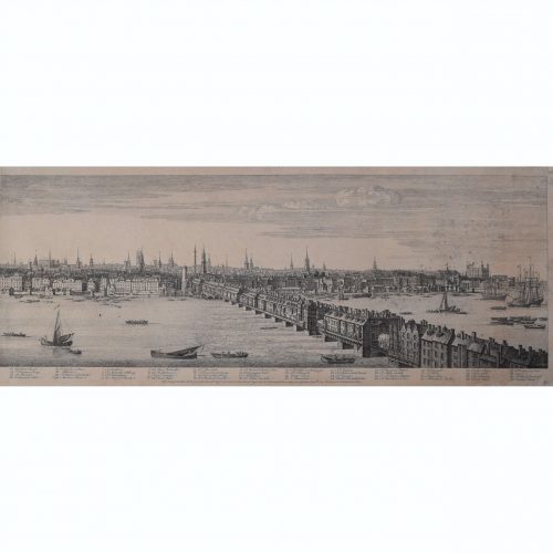
Samuel Buck (1696-1779) & Nathaniel Buck (active 1724-59) Panorama of the River Thames from Westminster Bridge to London Bridge
Published September 1749 30x404 cm Engraving Scroll down for further description. If you are interested email info@manningfineart.co.uk or call us on 07929 749056. -
Edward Quin (British 1794-1828)
Twenty-one maps from An Historical Atlas in a Series of Maps of the World As Known at Different Periods.
Twenty-one hand-coloured engraved maps, various sizes, presented in fine hand-finished rosewood veneer frames. Click on the image to see all twenty-one maps. 15 approx 40 x 31 cm 5 approx 62 x 31 cm Seeley and Burnside np. nd. [London c. 1830] Scroll down for further information.