-
Edward Quin (British 1794-1828)
Twenty-one maps from An Historical Atlas in a Series of Maps of the World As Known at Different Periods.
Twenty-one hand-coloured engraved maps, various sizes, presented in fine hand-finished rosewood veneer frames. Click on the image to see all twenty-one maps. 15 approx 40 x 31 cm 5 approx 62 x 31 cm Seeley and Burnside np. nd. [London c. 1830] Scroll down for further information. -
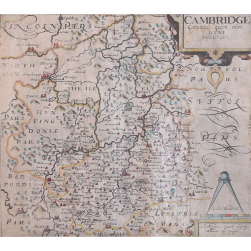
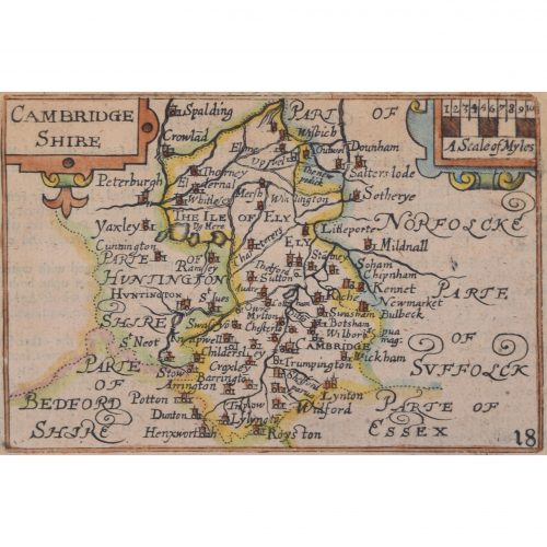
William Kip (active 1598 - 1610) after Christopher Saxton (1540 - 1610)
Map of Cambridgeshire (1637)
Engraving with later hand colouring 29 x 32 cm An antique map of Cambridgeshire. The map was originally published in William Camden's atlas 'Britannia', which was first published in 1586. William Kip was a goldsmith and map engraver. He was born in Utrecht in the Netherlands and moved to London to pursue his career as an engraver. Alongside William Hole, Kip re-engraved Christopher Saxton's 1574 county maps for publication in Camden's 'Britannia', and it is this venture for which he is most well-known. Christopher Saxton was an English cartographer who produced the first county maps of England and Wales. Between 1574 and 1578 he engraved maps of every county in Britain, and compiled them into an atlas in 1579. These maps bore Queen Elizabeth I's arms as well as those of Saxton's patron, Thomas Seckford. Condition: generally good; faint evidence of old staining. If you are interested, please email info@manningfineart.co.uk or call us on 07929 749056. Click here for more maps and general pictures of Cambridge. -
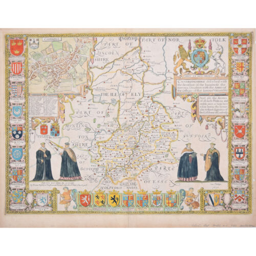
John Speed (1551 or 1552 - 1629)
Map of Cambridgeshire
Engraving with later hand colouring 39 x 53 cm A beautifully coloured map of Cambridgeshire, with an antique description of the county to the reverse. The map, along with many others, was published in Speed's atlas, 'The Theatre of the Empire of Great Britaine', first published in 1611. The map is populated by four figures in academic dress, and bordered on all sides by college crests. John Speed was an English cartographer, chronologer and historian. The son of a citizen and Merchant Taylor in London, he rose from his family occupation to accept the task of drawing together and revising the histories, topographies and maps of the Kingdoms of Great Britain as an exposition of the union of their monarchies in the person of King James I and VI. He accomplished this with remarkable success, with the support and assistance of the leading antiquarian scholars of his generation. He drew upon and improved the shire maps of Christopher Saxton, John Norden and others, being the first to incorporate the hundred-boundaries into them, and he was the surveyor and originator of many of the town or city plans inset within them. His work helped to define early modern concepts of British national identity. His Biblical genealogies were also formally associated with the first edition of the King James Bible. He is among the most famous of English mapmakers. Condition: generally very good; one tiny hole to right side just beyond plate mark. If you’d like to know more, please email info@manningfineart.co.uk or call us on 07929 749056. Click here for more Cambridge pictures. -
Pieter van den Keere (1571 - circa 1646) after John Speed (1551 or 1552 - 1629)
Map of Cambridgeshire (1627)
Engraving 8 x 12 cm A beautifully coloured map of Cambridgeshire, with an antique description of the county to the reverse. The map, along with many others, was published in Speed's atlas, 'The Theatre of the Empire of Great Britaine', first published in 1611. This particular miniature edition of the 'Theatre' was published in miniature by George Humble in 1627, entitled 'England Wales Scotland and Ireland Described and Abridged With ye Historic Relation of things worthy memory from a farr larger Voulume. Done by John Speed.’ Speed's original map was likely engraved for this edition by Peter van den Keere. van den Keere's maps soon came to be known as "Miniature Speeds". John Speed was an English cartographer, chronologer and historian. The son of a citizen and Merchant Taylor in London, he rose from his family occupation to accept the task of drawing together and revising the histories, topographies and maps of the Kingdoms of Great Britain as an exposition of the union of their monarchies in the person of King James I and VI. He accomplished this with remarkable success, with the support and assistance of the leading antiquarian scholars of his generation. He drew upon and improved the shire maps of Christopher Saxton, John Norden and others, being the first to incorporate the hundred-boundaries into them, and he was the surveyor and originator of many of the town or city plans inset within them. His work helped to define early modern concepts of British national identity. His Biblical genealogies were also formally associated with the first edition of the King James Bible. He is among the most famous of English mapmakers. George Humble (1572 - 1640) was an English publisher, known for his publication of John Speed's 'The theatre of the empire of Great Britaine,' the first comprehensive atlas depicting the British Isles, and his later 'A prospect of the most famous parts of the World,' the first English world atlas. Pieter van den Keere was a Flemish engraver, publisher, and globe maker who worked in England and the Dutch Republic. Condition: generally very good; some age toning. If you’d like to know more, please email info@manningfineart.co.uk or call us on 07929 749056. -
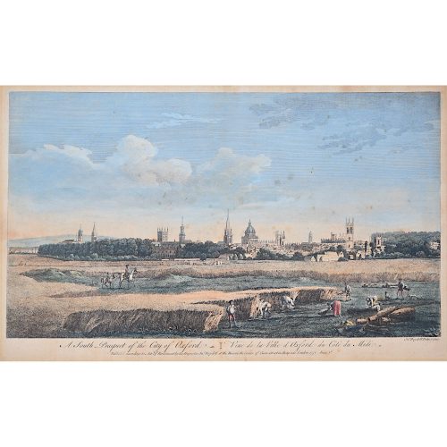
John Boydell (1719-1804)
A South Prospect of the City of Oxford
Hand-coloured engraving published 1751 in the series Four Views of Oxford 28x44.5cm If you are interested email info@manningfineart.co.uk or call us on 07929 749056. One of the most influential Georgian printsellers, Boydell was apprenticed to William Henry Toms at the age of 21, studying drawing at the St Marin's Lane Academy. From 1755 he imported foreign prints in great numbers. He became Mayor of London in 1790. -
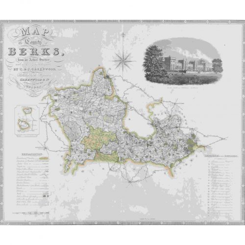
John Dower (1825 - 1901)
Map of Berkshire from an actual survey made in the years 1822 & 1823
Engraving 57 x 69 cm A large antique engraved map of Berkshire. Condition: good; some light staining. If you’d like to know more, please email info@manningfineart.co.uk or call us on 07929 749056. -
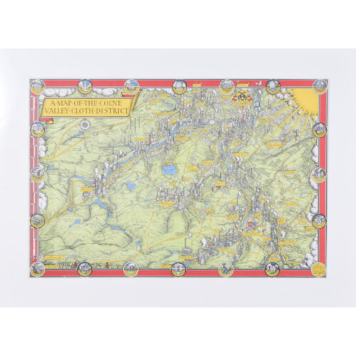
Leslie Macdonald "Max" Gill (1884 - 1947)
A Map of the Colne Valley Cloth District (1946)
Engraving with later hand-colouring 32 x 48 cm Signed in the plate and dated 1946. Produced for Huddersfield and District Woollen Export Group. Gill's vibrant and detailed map depicts the Colne Valley District. The Colne Valley was a loom-weaving area which played a significant role in the development of the Industrial Revolution when water-powered textile mills were brought in. Born in Brighton, Max Gill was the second son in a family of thirteen children; his elder brother was Eric Gill, the typographer and sculptor. Both Gills exhibited significant talent at a young age. Max Gill’s first map was made for a school map-drawing project following which he entered maps into competitions in boys’ magazines. In 1903 he moved to London as assistant to the ecclesiastical architects Sir Charles Nicholson and Hubert Corlette. By 1908 he had started his own architectural practice, but in 1909 Sir Edwin Lutyens commissioned Gill to paint a “wind dial” map for Nashdom, a large house in Buckinghamshire. The wind dial was set over the fireplace and attached to a weather vane on the roof, allowing the occupant to know the direction of the wind from the comfort of the house. He produced seven further wind dials including for Lutyens’s Lindisfarne Castle and for the Allhusen Room at Trinity College, Cambridge. Although Gill continued to practice as an architect, Frank Pick commissioned him to create seven pictorial maps for the Underground, the first being the famous 1913 ‘Wonderground Map of London Town.’ In 1917 he joined the Imperial War Graves Commission’s headstone design committee, designing the typeface and regimental badges. Gill’s memorials for the fallen in the First World War include for Balliol and Worcester Colleges and Christ Church in Oxford. During the 1920s and 30s Gill undertook many commercial commissions for advertising materials. The Empire Marketing Board and Shell-Mex as well as further maps for the Underground. He designed in 1922 the first diagrammatic map of the Underground which provided the foundation for Beck’s more famous map. By the 1930s his major works were murals. Those of the Arctic and Antarctic on the ceilings of the Scott Polar Research Institute in Cambridge are beautiful, but the most impressive is the map of the North Atlantic in the first-class dining room of the Queen Mary (maiden voyage: 1936, now moored at Long Beach, California). During the Second World War he created a series of propaganda posters for the Ministry of Information. Condition: very good. In new hand-finished frame. If you are interested, please email info@manningfineart.co.uk or call us on 07929 749056. Click here for other decorative maps. -
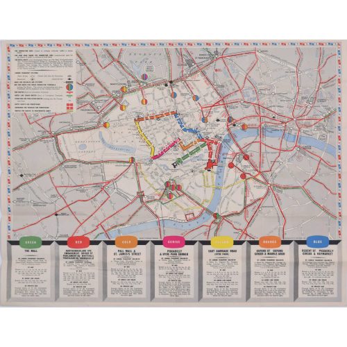
Coronation Arrangements - Map of London (1953)
Lithograph 45 x 60 cm (unfolded) Published by London Transport for the Coronation of Elizabeth II, this delightfully-coloured map illustrates the route taken by the Queen when she was crowned in 1953. Condition: generally very good. If you are interested, please email info@manningfineart.co.uk or call us on 07929 749056. -
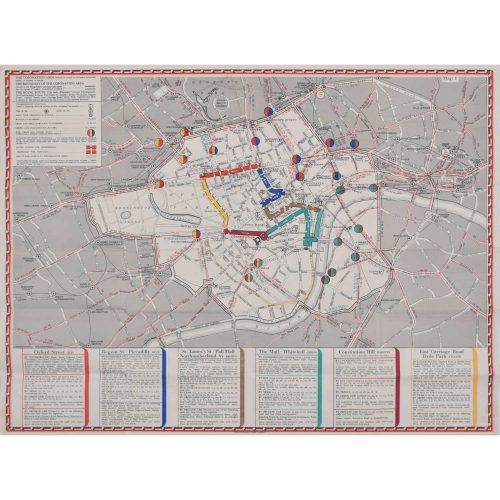
Coronation Arrangements - Map of London (1937)
Lithograph 45 x 60 cm (unfolded) Published by London Transport for the Coronation of George VI, this map illustrates the route the King took in 1936. And best of all, it's just (almost!) as useful in today's London. Condition: generally very good. If you are interested, please email info@manningfineart.co.uk or call us on 07929 749056. -
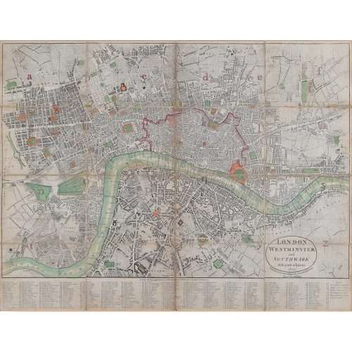
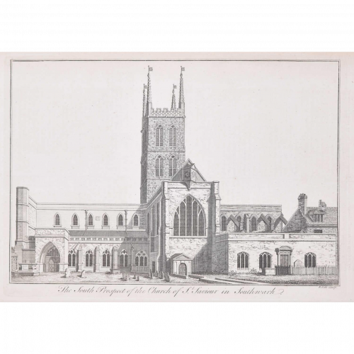
Darton and Harvey (publisher)
Map of London, Southwark, and parts adjacent (1800)
Engraving 42 x 56 cm Condition: generally very good; backed to linen with some evidence of use.