Macdonald Gill – ‘Max Gill’ (1884-1947)
Born in Brighton, Max Gill was the second son in a family of thirteen children; his elder brother was Eric Gill, the typographer and sculptor. Both Gills exhibited significant talent at a young age. Max Gill’s first map was made for a school map-drawing project following which he entered maps into competitions in boys’ magazines.
In 1903 he moved to London as assistant to the ecclesiastical architects Sir Charles Nicholson and Hubert Corlette. By 1908 he had started his own architectural practice, but in 1909 Sir Edwin Lutyens commissioned Gill to paint a “wind dial” map for Nashdom, a large house in Buckinghamshire. The wind dial was set over the fireplace and attached to a weather vane on the roof, allowing the occupant to know the direction of the wind from the comfort of the house. He produced seven further wind dials including for Lutyens’s Lindisfarne Castle and for the Allhusen Room at Trinity College, Cambridge.
Although he continued to practice as an architect, Frank Pick commissioned him to create seven pictorial maps for the Underground, the first being the famous 1913 ‘Wonderground Map of London Town.’
In 1917 he joined the Imperial War Graves Commission’s headstone design committee, designing the typeface and regimental badges. Gill’s memorials for the fallen in the First World War include for: Balliol and Worcester Colleges and Christ Church in Oxford.
During the 1920s and 30s Gill undertook many commercial commissions for advertising materials. The Empire Marketing Board and Shell-Mex as well as further maps for the Underground. He designed in 1922 the first diagrammatic map of the Underground which provided the foundation for Beck’s more famous map.
By the 1930s his major works were murals. Those of the Arctic and Antarctic on the ceilings of the Scott Polar Research Institute in Cambridge are beautiful, but the most impressive is the map of the North Atlantic in the first-class dining room of the Queen Mary (maiden voyage: 1936, now moored at Long Beach, California).
During the Second World War he created a series of propaganda posters for the Ministry of Information; this map is from that series.
-
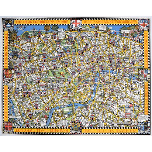
Macdonald (Max) Gill (1884-1947) Wonderground Map of London (c. 1924, after 1914 original edition)
Lithographic poster 75x94cm In the present work, in the top left-hand corner it reads 'On to Wembley' making reference to the British Empire Exhibition of 1924. Gill's original 1914 poster was hugely popular and reprinted with updates to feature topical events. Born in Brighton, Max Gill was the second son in a family of thirteen children; his elder brother was Eric Gill, the typographer and sculptor. Both Gills exhibited significant talent at a young age. Max Gill’s first map was made for a school map-drawing project following which he entered maps into competitions in boys’ magazines. In 1903 he moved to London as assistant to the ecclesiastical architects Sir Charles Nicholson and Hubert Corlette. By 1908 he had started his own architectural practice, but in 1909 Sir Edwin Lutyens commissioned Gill to paint a “wind dial” map for Nashdom, a large house in Buckinghamshire. The wind dial was set over the fireplace and attached to a weather vane on the roof, allowing the occupant to know the direction of the wind from the comfort of the house. He produced seven further wind dials including for Lutyens’s Lindisfarne Castle and for the Allhusen Room at Trinity College, Cambridge. Although he continued to practice as an architect, Frank Pick commissioned him to create seven pictorial maps for the Underground, the first being the famous 1913 ‘Wonderground Map of London Town.’ In 1917 he joined the Imperial War Graves Commission’s headstone design committee, designing the typeface and regimental badges. Gill’s memorials for the fallen in the First World War include for Balliol and Worcester Colleges and Christ Church in Oxford. During the 1920s and 30s Gill undertook many commercial commissions for advertising materials. The Empire Marketing Board and Shell-Mex as well as further maps for the Underground. He designed in 1922 the first diagrammatic map of the Underground which provided the foundation for Beck’s more famous map. By the 1930s his major works were murals. Those of the Arctic and Antarctic on the ceilings of the Scott Polar Research Institute in Cambridge are beautiful, but the most impressive is the map of the North Atlantic in the first-class dining room of the Queen Mary (maiden voyage: 1936, now moored at Long Beach, California). During the Second World War he created a series of propaganda posters for the Ministry of Information. -

Macdonald (Max) Gill (1884-1947)
Australia: Her Natural and Industrial Resources (1950)
His Majesty’s Stationary Office, SO Code NO. 70-538-5-2 Lithographic poster 51 x 76cm (20 x 30 inches) Click here for biographical details and other works by the artist. Condition generally very good, a little spotting and the odd very short edge tear to margin not affecting image. If you are interested email info@manningfineart.co.uk or call us on 07929 749056.