-
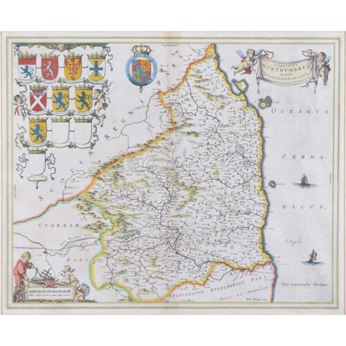
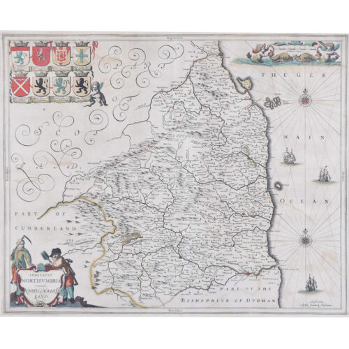
Johannes 'Joan' Blaeu (1596 - 1673)
Comitatus Northumbria, Vernacular Northumberland (1662)
Engraving with later hand-colouring 43 x 52 cm A decorative map of Northumberland by the celebrated Dutch mapmaker and artist Joan Blaeu, (son of the cartographer Willem Blaeu). Crests of the local gentry appear in the top right hand corner. Blaeu moved to Amsterdam in 1920 to join the family firm of mapmakers. In 1635, the business published the Theatrum orbis terrarum, sive, Atlas novus in two volumes - the largest and most expensive book published in the seventeenth century, and the venture for which the Blaeu were most famed. Joan and his brother Cornelius took over the studio after their father died in 1638; Joan became the official cartographer for the Dutch East India Company, as his father had been before him. Condition: very good. If you are interested, please email info@manningfineart.co.uk or call us on 07929 749056. Click here for other maps. -
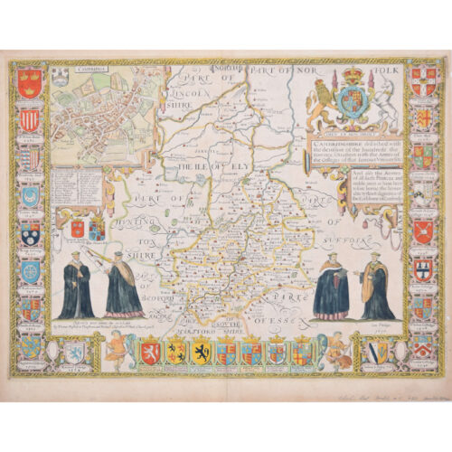
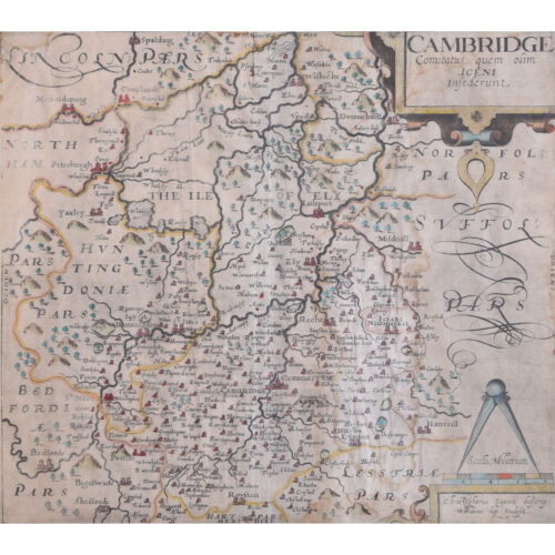
John Speed (1551 or 1552 - 1629)
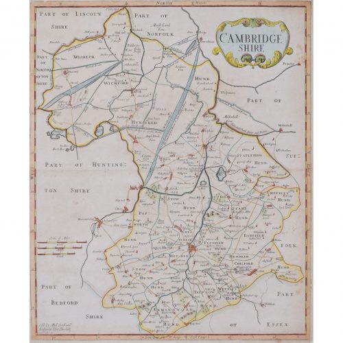
Map of Cambridgeshire
Engraving with later hand colouring 39 x 53 cm A beautifully coloured map of Cambridgeshire, with an antique description of the county to the reverse. The map, along with many others, was published in Speed's atlas, 'The Theatre of the Empire of Great Britaine', first published in 1611. The map is populated by four figures in academic dress, and bordered on all sides by college crests. John Speed was an English cartographer, chronologer and historian. The son of a citizen and Merchant Taylor in London, he rose from his family occupation to accept the task of drawing together and revising the histories, topographies and maps of the Kingdoms of Great Britain as an exposition of the union of their monarchies in the person of King James I and VI. He accomplished this with remarkable success, with the support and assistance of the leading antiquarian scholars of his generation. He drew upon and improved the shire maps of Christopher Saxton, John Norden and others, being the first to incorporate the hundred-boundaries into them, and he was the surveyor and originator of many of the town or city plans inset within them. His work helped to define early modern concepts of British national identity. His Biblical genealogies were also formally associated with the first edition of the King James Bible. He is among the most famous of English mapmakers. Condition: generally very good; one tiny hole to right side just beyond plate mark. If you’d like to know more, please email info@manningfineart.co.uk or call us on 07929 749056. Click here for more Cambridge pictures. -
William Kip (active 1598 - 1610) after Christopher Saxton (1540 - 1610)
Map of Cambridgeshire (1637)
Engraving with later hand colouring 29 x 32 cm An antique map of Cambridgeshire. The map was originally published in William Camden's atlas 'Britannia', which was first published in 1586. William Kip was a goldsmith and map engraver. He was born in Utrecht in the Netherlands and moved to London to pursue his career as an engraver. Alongside William Hole, Kip re-engraved Christopher Saxton's 1574 county maps for publication in Camden's 'Britannia', and it is this venture for which he is most well-known. Christopher Saxton was an English cartographer who produced the first county maps of England and Wales. Between 1574 and 1578 he engraved maps of every county in Britain, and compiled them into an atlas in 1579. These maps bore Queen Elizabeth I's arms as well as those of Saxton's patron, Thomas Seckford. Condition: generally good; faint evidence of old staining. If you are interested, please email info@manningfineart.co.uk or call us on 07929 749056. Click here for more maps and general pictures of Cambridge. -
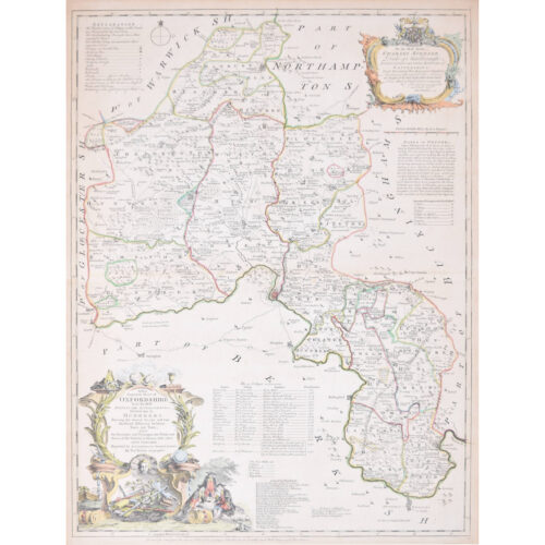
Thomas Kitchin (1719 - 1784)
Map of Oxfordshire (1764)
Engraving with later hand-colouring 72 x 54 cm This decorative map of Oxfordshire features a cartouche with three concentrating scholars and various educational trappings like rolls of parchment. The cartouche in the upper right corner dedicates the map to Charles Spencer, Duke of Marlborough, whose family seat of Blenheim Palace is just outside the city of Oxford. The map also sports a list of the University of Oxford's colleges, its rectories and vicarages, and a paragraph on the Earls of Oxford. Thomas Kitchin was an English engraver and cartographer. He was born in London and was apprenticed to the map engraver Emanuel Bowen in 1732. He produced John Elphinstone's map of Scotland (1746), the Geographia Scotiae (1749), and The Small English Atlas (1749) with Thomas Jefferys. Kitchen worked for the London Magazine and for the King; there is also some debate as to whether he passed off other cartographers' work as his own. Condition: generally very good; central fold as issued, another fold to middle of top half, three tiny losses (a millimetre or two) just outside plate mark to left side. If you are interested, please email info@manningfineart.co.uk or call us on 07929 749056. Click here for other decorative maps. -
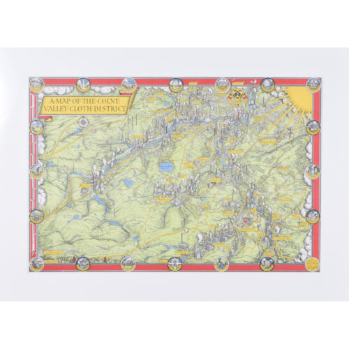
Leslie Macdonald "Max" Gill (1884 - 1947)
A Map of the Colne Valley Cloth District (1946)
Engraving with later hand-colouring 32 x 48 cm Signed in the plate and dated 1946. Produced for Huddersfield and District Woollen Export Group. Gill's vibrant and detailed map depicts the Colne Valley District. The Colne Valley was a loom-weaving area which played a significant role in the development of the Industrial Revolution when water-powered textile mills were brought in. Born in Brighton, Max Gill was the second son in a family of thirteen children; his elder brother was Eric Gill, the typographer and sculptor. Both Gills exhibited significant talent at a young age. Max Gill’s first map was made for a school map-drawing project following which he entered maps into competitions in boys’ magazines. In 1903 he moved to London as assistant to the ecclesiastical architects Sir Charles Nicholson and Hubert Corlette. By 1908 he had started his own architectural practice, but in 1909 Sir Edwin Lutyens commissioned Gill to paint a “wind dial” map for Nashdom, a large house in Buckinghamshire. The wind dial was set over the fireplace and attached to a weather vane on the roof, allowing the occupant to know the direction of the wind from the comfort of the house. He produced seven further wind dials including for Lutyens’s Lindisfarne Castle and for the Allhusen Room at Trinity College, Cambridge. Although Gill continued to practice as an architect, Frank Pick commissioned him to create seven pictorial maps for the Underground, the first being the famous 1913 ‘Wonderground Map of London Town.’ In 1917 he joined the Imperial War Graves Commission’s headstone design committee, designing the typeface and regimental badges. Gill’s memorials for the fallen in the First World War include for Balliol and Worcester Colleges and Christ Church in Oxford. During the 1920s and 30s Gill undertook many commercial commissions for advertising materials. The Empire Marketing Board and Shell-Mex as well as further maps for the Underground. He designed in 1922 the first diagrammatic map of the Underground which provided the foundation for Beck’s more famous map. By the 1930s his major works were murals. Those of the Arctic and Antarctic on the ceilings of the Scott Polar Research Institute in Cambridge are beautiful, but the most impressive is the map of the North Atlantic in the first-class dining room of the Queen Mary (maiden voyage: 1936, now moored at Long Beach, California). During the Second World War he created a series of propaganda posters for the Ministry of Information. Condition: very good. In new hand-finished frame. If you are interested, please email info@manningfineart.co.uk or call us on 07929 749056. Click here for other decorative maps. -
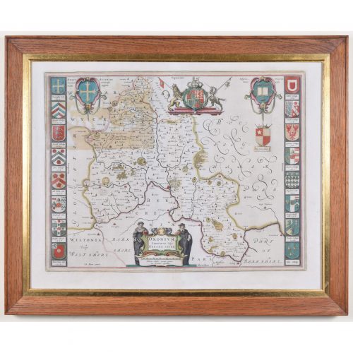
Johannes 'Joan' Blaeu (1596 - 1673)
Oxonium Comitatus, Vulgo Oxfordshire (1662)
Engraving with later hand-colouring 38 x 50 cm A decorative map of Oxfordshire by the celebrated Dutch mapmaker and artist Joan Blaeu, (son of the cartographer Willem Blaeu). Two Oxford scholars flanks the cartouche which declares the map to be of Oxonium (that is, Oxfordshire), and the design also features the arms of the British Royal Family, King Alfred, and the University of Oxford. Sixteen colleges crests border the map. Blaeu moved to Amsterdam in 1920 to join the family firm of mapmakers. In 1635, the business published the Theatrum orbis terrarum, sive, Atlas novus in two volumes - the largest and most expensive book published in the seventeenth century, and the venture for which the Blaeu were most famed. Joan and his brother Cornelius took over the studio after their father died in 1638; Joan became the official cartographer for the Dutch East India Company, as his father had been before him. Condition: mostly very good; area of toning to top left where coloured to reverse. Good oak frame. Framed with reverse visible. If you are interested, please email info@manningfineart.co.uk or call us on 07929 749056. Click here for other antique maps. -
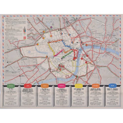
Coronation Arrangements - Map of London (1953)
Lithograph 45 x 60 cm (unfolded) Published by London Transport for the Coronation of Elizabeth II, this delightfully-coloured map illustrates the route taken by the Queen when she was crowned in 1953. Condition: generally very good. If you are interested, please email info@manningfineart.co.uk or call us on 07929 749056. -
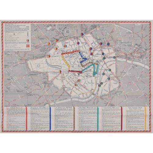
Coronation Arrangements - Map of London (1937)
Lithograph 45 x 60 cm (unfolded) Published by London Transport for the Coronation of George VI, this map illustrates the route the King took in 1936. And best of all, it's just (almost!) as useful in today's London. Condition: generally very good. If you are interested, please email info@manningfineart.co.uk or call us on 07929 749056. -
Sutton Nichols (1668 - 1729)
Map of Cambridgeshire
Engraving 43 x 36 cm Signed in plate lower left. A beautifully coloured 18th century map engraving of Cambridgeshire. The map was produced by Robert Morden for publication in Edward Gibson's 1695 translation of William Camden's Britannia, a topographical and historical survey of Great Britain and Ireland produced to "restore antiquity to Britaine, and Britain to his antiquity" - a most noble aim. William Camden (1551 - 1623) was an English antiquarian, historian, topographer, and herald, best known as the author of Britannia, the first chorographical survey of the islands of Great Britain and Ireland, and the Annales, the first detailed historical account of the Queen Elizabeth I's reign. Sutton Nicholls was a draughtsman and engraver best known for his panoramic views of the cities of London and Westminster. Almost all of his engravings were commissioned by publishers. Nicholls specialised in topographical and architectural designs; he also produced many maps, notably illustrating John Strype’s edition of John Stowe’s ‘Survey of London’ in 1720. Condition: good. Mounted to board. If you’d like to know more, please email info@manningfineart.co.uk or call us on 07929 749056. -
Pieter van den Keere (1571 - circa 1646) after John Speed (1551 or 1552 - 1629)
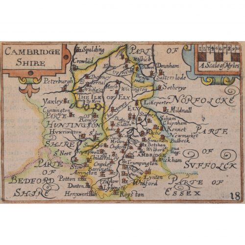
Map of Cambridgeshire (1627)
Engraving 8 x 12 cm A beautifully coloured map of Cambridgeshire, with an antique description of the county to the reverse. The map, along with many others, was published in Speed's atlas, 'The Theatre of the Empire of Great Britaine', first published in 1611. This particular miniature edition of the 'Theatre' was published in miniature by George Humble in 1627, entitled 'England Wales Scotland and Ireland Described and Abridged With ye Historic Relation of things worthy memory from a farr larger Voulume. Done by John Speed.’ Speed's original map was likely engraved for this edition by Peter van den Keere. van den Keere's maps soon came to be known as "Miniature Speeds". John Speed was an English cartographer, chronologer and historian. The son of a citizen and Merchant Taylor in London, he rose from his family occupation to accept the task of drawing together and revising the histories, topographies and maps of the Kingdoms of Great Britain as an exposition of the union of their monarchies in the person of King James I and VI. He accomplished this with remarkable success, with the support and assistance of the leading antiquarian scholars of his generation. He drew upon and improved the shire maps of Christopher Saxton, John Norden and others, being the first to incorporate the hundred-boundaries into them, and he was the surveyor and originator of many of the town or city plans inset within them. His work helped to define early modern concepts of British national identity. His Biblical genealogies were also formally associated with the first edition of the King James Bible. He is among the most famous of English mapmakers. George Humble (1572 - 1640) was an English publisher, known for his publication of John Speed's 'The theatre of the empire of Great Britaine,' the first comprehensive atlas depicting the British Isles, and his later 'A prospect of the most famous parts of the World,' the first English world atlas. Pieter van den Keere was a Flemish engraver, publisher, and globe maker who worked in England and the Dutch Republic. Condition: generally very good; some age toning. If you’d like to know more, please email info@manningfineart.co.uk or call us on 07929 749056. -
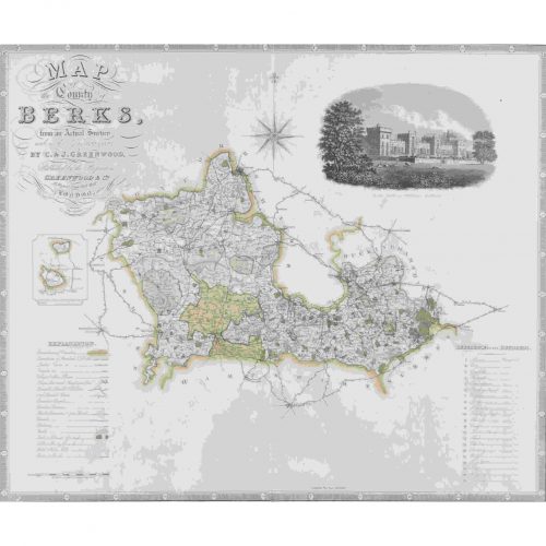
John Dower (1825 - 1901)
Map of Berkshire from an actual survey made in the years 1822 & 1823
Engraving 57 x 69 cm A large antique engraved map of Berkshire. Condition: good; some light staining. If you’d like to know more, please email info@manningfineart.co.uk or call us on 07929 749056. -
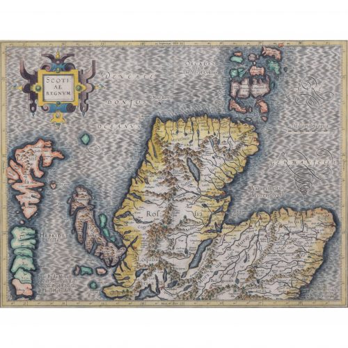
Gerardus Mercator (1512 - 1594)
Map of the North of Scotland (1683)
Engraving with later hand colouring 35 x 45 cm A fantastically characterful and detailed map engraving of the North of Scotland from 1683. The highly detailed and beautifully coloured map is inscribed to the reverse with a description of the parts of Scotland illustrated, called the ''Troisieme Table d''Escosse''. The map comes from the 1683 French edition of Gerardus Mercator''s Atlas Major, which was first published in 1585. Gerardus Mercator was the Flemish father of mapmaking. He was a skilled geographer, cosmographer and cartographer and is most renowned for creating the 1569 world map based on a new projection which represented sailing courses of constant bearing (rhumb lines) as straight lines - an innovation that is still employed in today''s nautical charts. Mercator was a highly influential pioneer in the history of cartography and is generally considered one of the founders of the Netherlandish school of cartography and geography. He is also widely considered the most notable figure of the school. In his own day, he was a notable maker of globes and scientific instruments. In addition, he had interests in theology, philosophy, history, mathematics and geomagnetism. He was also an accomplished engraver and calligrapher. Unlike other great scholars of the age, he travelled little and his knowledge of geography came from his library of over a thousand books and maps, from his visitors and from his vast correspondence (in six languages) with other scholars, statesmen, travellers, merchants and seamen. Mercator''s early maps were in large formats suitable for wall mounting but in the second half of his life, he produced over 100 new regional maps in a smaller format suitable for binding into his Atlas of 1595. This was the first appearance of the word Atlas in reference to a book of maps. However, Mercator used it as a neologism for a treatise (Cosmologia) on the creation, history and description of the universe, not simply a collection of maps. He chose the word as a commemoration of the Titan Atlas, "King of Mauretania", whom he considered to be the first great geographer. Mercator wrote on geography, philosophy, chronology and theology. All of the wall maps were engraved with copious text on the region concerned. As an example, the famous world map of 1569 is inscribed with over five thousand words in fifteen legends. Condition: a little spotting, primarily to margins. If you’d like to know more, please email info@manningfineart.co.uk or call us on 07929 749056. -
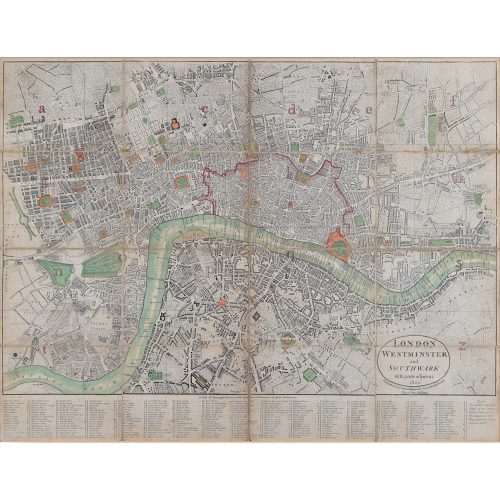
Darton and Harvey (publisher)
Map of London, Southwark, and parts adjacent (1800)
Engraving 42 x 56 cm Condition: generally very good; backed to linen with some evidence of use. -
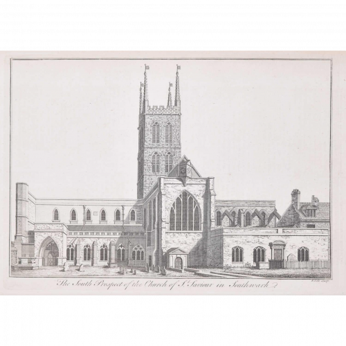
Benjamin Cole (1697-1783)
Southwark Cathedral (c. 1753)
Engraving 24 x 33 cm Stow's Survey of London, a ward-by-ward topographical and historical tour of the City of London giving an account of buildings, social conditions and customs, was first published in 1598. This view of Southwark Cathedral, labelled here as 'the South Prospect of the Church of St Saviour in Southwark', offers a charming perspective of the building's architecture and churchyard. Condition: Generally very good; slight offsetting from facing page and old library stamp to reverse. -
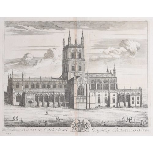
Johannes 'Jan' Kip (1652/3 - 1722)
The North Prospect of Gloster Cathedral (c.1716)
43 x 47 cm Copper engraving Johannes "Jan" Kip was a Dutch engraver, draughtsman and print dealer. After producing works for the court of William of Orange in Amsterdam, Kip followed William and Mary to London, settling in Farringdon and selling prints. Later, Kip collaborated with draughtsman and painter Leonard Knyff, and together they made a popular series of engraved views of English country houses. This print is from Sir Robert Atkyn's 'The Ancient and Present State of Gloucestershire'. In his usual manner - Kip was probably the foremost engraver of his time in England - he has placed figures before the Cathedral to give life - and scale - to the building. Condition: Generally very good with central vertical fold and adjacent parallel creases; one diagonal crease mid left to bottom centre. Will look very good when framed.